

Salisbury: Rehabilitating the Scalds
A regenerative agriculture case study from The Marra, north-central NSW.
In the 1980s, portions of Salisbury were fit for one thing and one thing only: landing an aeroplane. Since then, the MacAlpine family has rehabilitated much of this scalded land and developed a number of strategies to make their property ready for both the droughts and flooding rains that this part of the country is prone to.
Salisbury, The Marra, NSW
FARM FACTS
ENTERPRISE: Self-replacing merino flock
PROPERTY SIZE: 20,000 hectares
AVERAGE ANNUAL RAINFALL: Approximately 450 mm
ELEVATION: 133 m
MOTIVATION FOR CHANGE: Improve the health and condition of the sheep, primarily through improving the health and condition of the pastures
INNOVATIONS
- Reclaiming scalded red duplex country through “waterponding”
- Manage total grazing pressure with wildlife-proof fencing
- Manage sheep numbers via trigger point assessments at key points in the annual cycle
- Manage water infrastructure
- Supplementary feeding to assist breeding
KEY RESULTS
- Approximately a quarter of the property (most of the scalded red country) has been treated with waterponds.
- Several paddocks have been enclosed with wildlife proof fencing.
- Sheep numbers are being managed via decisions on numbers to join and disposal to sale or to brother’s property at Grenfell, NSW.
- Three of the four artesian bores on the property have been capped and piped to tanks – each with two troughs.
- Supplementary feeding infrastructure established.
About Salisbury
The Property
The Salisbury property is located on the floodplain and associated relict red duplex terraces of the Marra Creek, to the west of the Macquarie Marshes about 160 km north-west of Warren in north-central New South Wales. The Queensland border is about 160 km further north. Carinda – the nearest town – is about 60 km north-east. Marra Creek runs through the region. It adjoins Salisbury on the property’s western side and potentially flows north into the Barwon River, a tributary of the Darling River.
Salisbury is about 20,000 hectares. The MacAlpines consider that area can support a self-replacing merino flock totalling about 10,000 dry sheep equivalents, typically comprising 5000 breeding ewes (1.5 DSE each) and 2500 ewe lambs, on average in the long term (and allowing for the kangaroos!). The property is subdivided into 22 main paddocks and a few holding yards and transport routes.
Salisbury was previously part of the Womboin Station, which was owned by the Dalgety company. Womboin was subdivided in 1972. The MacAlpine family purchased the Salisbury part in 1977 and added two adjoining blocks soon after. Half of Salisbury is on dark heavy clay soil that is relatively impervious to erosion. This rest is red soil that has a better natural potential for grazing has been degraded by wind and water erosion.
The Ecological Assessment
Ecological Assessment
All functional criteria in are considered to have improved since 1972. For example, since the widespread adoption of regenerative practices in 2009:
• the property is becoming more resilient to drought. A similar conclusion is likely for flood proofing
• soil health and function has gradually improved
• vegetation biodiversity has stayed much the same during the waterponding operations
• pasture status has gradually improved (from zero) in the ponded areas, due to increased ground cover and herb species richness.
The reproductive potential of the plant species and plant community has similarly improved.
More improvement in these values is expected in future, particularly when drought conditions ease. Further rainfall will serve to leach salts from surface layers of the scalds as well as provide an essential input for plant growth.
The Social Report
Social Report
The MacAlpine vision for regenerative agriculture developed and evolved over many years of experience to meet perceived needs of the family and their country. Their broad aim is to remain profitable while not degrading (or, where possible, improving) their asset base and its resilience to drought. Their early grazing practices noticeably degraded the country and its resilience, so they were always on the lookout for better ways of managing their stock and country.
Grant made all management decisions in the early days. Will is now joint manager with a focus on the stock. Strategic decisions for Salisbury are made by Grant, Cathy and Will at weekly meetings. Rather than a formal risk management framework, the family makes judgements based on the accumulated wisdom gained from years of experience on the property and the experience of neighbours.
The Economic Report
Economic Report
The regenerative farming practices that the MacAlpines have implemented on Salisbury have led to significantly increased production levels when compared to the Average Farm. With increased productivity, the income generated on Salisbury is also significantly higher than that of the Average Farm.
Tour the farm with Will MacAlpine
Ready for drought, ready for rain
Salisbury is typical of Dorothea McKellar’s ‘land of droughts and flooding rains’. There are no permanent watercourses on Salisbury. Water supply is rain and bores that tap the Great Artesian Basin. Average annual rainfall is about 450 mm on the property or 405 mm as measured at the nearest meteorological station, perhaps indicating high local variability. The average and median monthly rainfall sometimes falls in a single day, sometimes causing regional flooding. Conversely, very little rain falls for substantial periods.
Will MacAlpine is clear that for the grazing business to cope, obtaining maximum benefit from rainfall events and minimum damage during dry periods, ‘we must be ready for drought, and we must be ready for rain’. The strategy to achieve that comprises a number of tactics:
- Increase the area of productive grazing land by rehabilitating scalded land.
- Cap the artesian bores to control water supply.
- Control kangaroo grazing pressure.
- Manage sheep grazing pressure in dry periods by moving sheep to holding pens and hand feeding them, and by deferring joining young ewes.
In practice, these tactics are interlinked or interdependent.
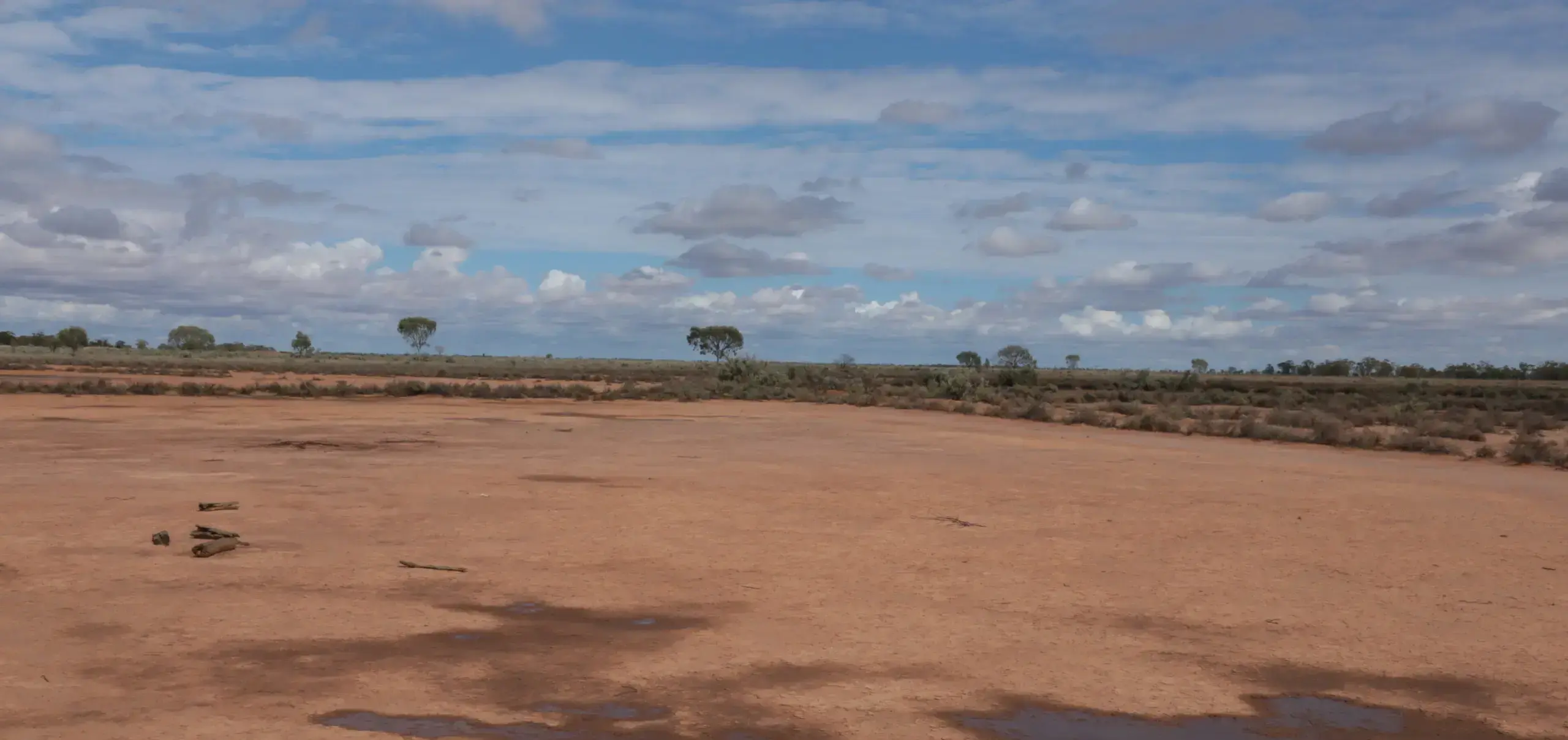
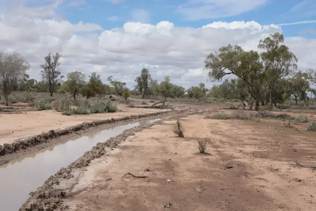
Rehabilitating the scalds
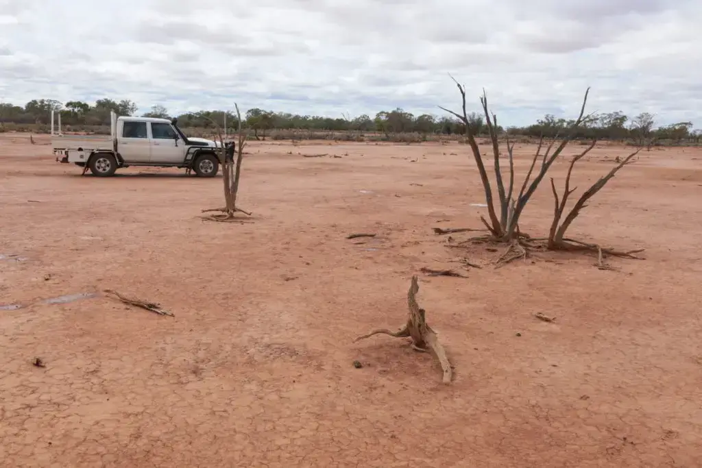
A scald on Salisbury, still remaining in 2020, showing the hard-packed surface soil and elevated root systems of dead plants, indicating the depth of topsoil lost to wind and water erosion.
Although rehabilitation work was begun on Salisbury in the 1970s by the previous owners, when the MacAlpines took over the property Grant MacAlpine could land his light plane almost anywhere on the property. After seeing promising results on properties nearby, the MacAlpine family continued rehabilitation in the 1980s and 1990s. Works ramped up in 2009 and 2012 when government grants were available.
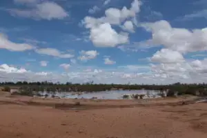
The methods that have been used successfully for several years on Salisbury involve using a grader to build low ponding banks to hold rainwater to a depth of 10 cm or so. These are circular on flat ground and semi-circular (a ‘horseshoe’ shape) on scald with a mild slope. The opening of the horseshoe is to the up-slope side, so that run-off collects within the banks. Each pond covers about 0.4 hectares. The grader used to construct the banks is also used to disturb the soil surface within the ponds in strategic locations (Thompson 2008). Saltbush seed – some of it collected on the property – is sown over the disturbed surface. Running cattle over the ponded area after the surface had been softened by rain was used to disturb the soil surface in a previous Soils For Life case study of a property near Brewarrina.
The effect of the ponding banks and disturbance is to hold water from the intermittent heavy falls. This then infiltrates – albeit slowly – to leach salts from the surface and provide moisture down the soil profile. The banks and disturbance within them provide a barrier to wind-blown sediments and plant material, which collects and starts to form an organic-rich surface layer. The saltbush seed, together with whatever seed is delivered by wind, sheep and birds, then has somewhere to germinate and moisture to tap in the soil profile. The natural processes of ecological succession have effectively been given a ‘kick-start’ and can take their course. To date, about half of the scalded areas on Salisbury have been treated in this way.
The results can be seen here:
-

Pond created in 2009. Note soil loss from parts of the bank.
-
Pond created in 2012. Note saltbushes growing in the rip line and posts used for monitoring.
-
A horseshoe pond bank with water ponding in the trenches either side of the bank and across the surface. Regenerating vegetation is evident within the horseshoe.

Capping the bores
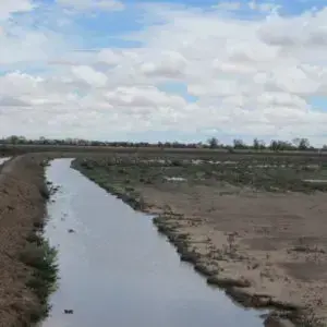
Four artesian bores that were installed early in the 20th century and have been flowing ever since supplement Salisbury’s intermittent water supply from rainfall. The aggregate potential flow rate is 9 L/second (284 ML/year, or about 114 Olympic swimming pools). However, the volume required to support grazing stock is estimated at around 1 L/second, so the rest (around 250 ML/year) runs away to waste via bore drains. The wasted water supports a kangaroo population far in excess of what would be there naturally, whereas a tank and trough system can be managed to restrict water supply.
One of the four bore drains that together used to carry away around 250 Ml/year of surplus water.
Capping the bores maintained the pressure of the underground artesian aquifer and used only the amount of water needed for stock. A threat by governments to charge for water used in excess of stock requirements focused the MacAlpines’ action. A subsidy from the NSW Government [1] helped too. Following the mandated specifications, each tank supplies two nearby troughs – the second being presumably for backup in case one failed. So far, two of the four bores on Salisbury have been capped.
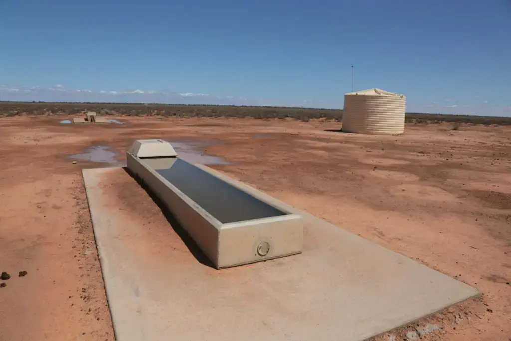
Tank and troughs that have replaced free-flowing artesian bores.
Managing grazing pressure
This is the biggest concern for the viability of the Salisbury business is a seemingly endless supply of kangaroos willing to move on to the property. Generally, they come from the north and arguably in far higher numbers than would have been possible before graziers started providing water sources.
Managing the kangaroo population requires a massive investment in specifically designed fencing. Fences like that will also exclude wild dogs that be-devil sheep graziers elsewhere and that the MacAlpines expect in the Marra region before long.
The cost of kangaroo-proof fencing is around $4,000/km for materials and the property boundary is about 50 km, so a substantial investment is required. Fortunately, the NSW Government has provided a low-interest loan for this.
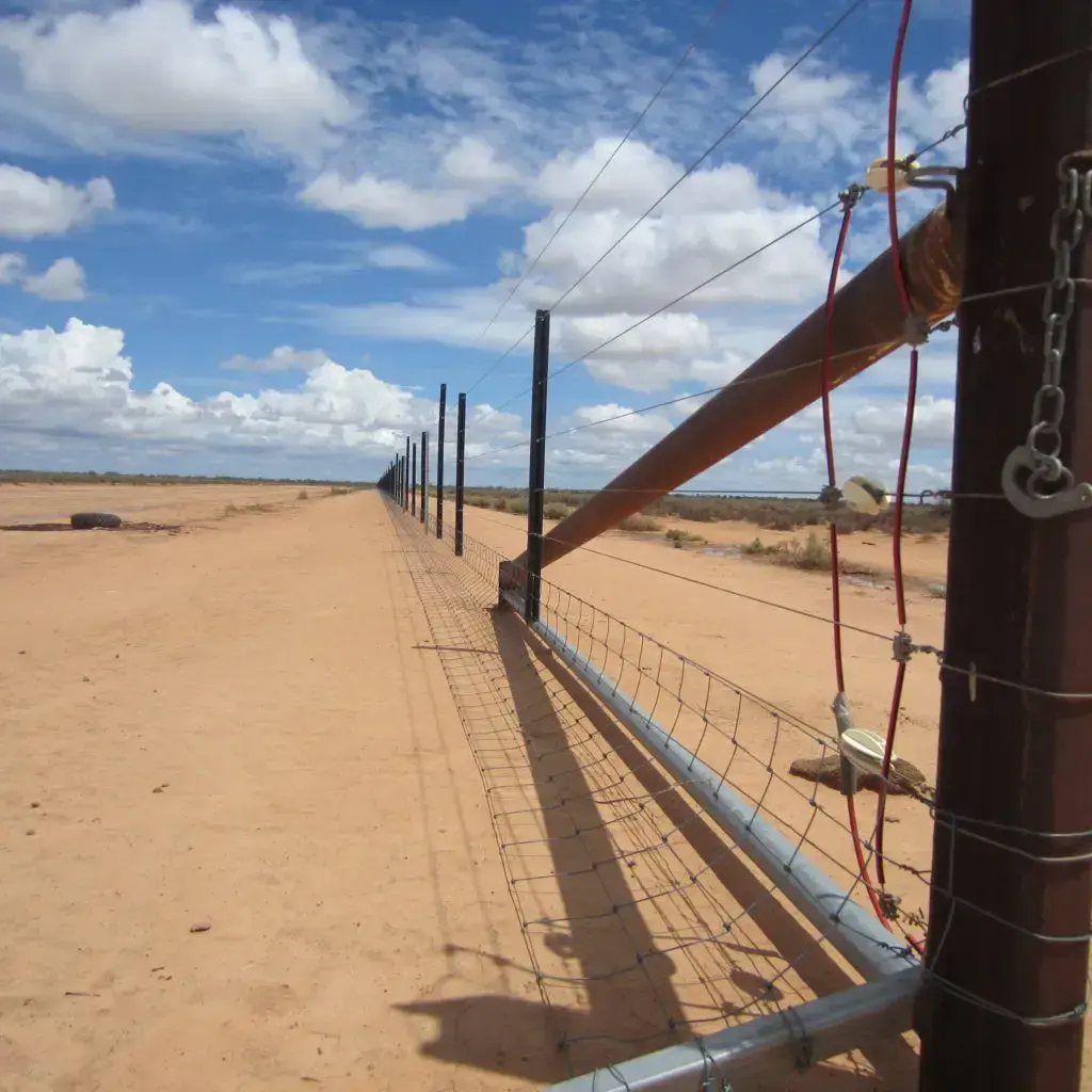
Kangaroo-proof fence: extra height wire supported by fewer posts; mesh apron to prevent kangaroos pushing under the bottom wire; two electrified mid height wires powered by solar panels.
Sheep grazing pressure is managed in dry periods by moving sheep to holding pens and hand feeding them with grain and straw. This is especially useful for ensuring that ewes chosen for breeding have optimum nutrition.
Further tactics to reduce grazing pressure include:
- deferring joining young ewes so that their grazing requirements are minimised; and
- selling older ewes or passing them on to the farm run by Alex MacAlpine at Grenfell, NSW.
Will and Grant MacAlpine make these decisions from time to time [2], taking particular note of animal and pasture health.
Adapted to a variable climate
In summary, the grazing enterprise at Salisbury is well adapted to the highly variable, semi-arid climate. Amongst their many benefits, the water ponds bring more areas into production and generally improve the appearance of the property. Capping the bore, erecting wildlife-proof fencing and managing stock numbers controls the total grazing pressure and ensures sustainability so that the MacAlpines are ready for drought and ready for rain.
[1] Not as generous as the subsidy in Queensland.
[2] Especially over the summer period when a “feed gap” would develop if rain was inadequate.
References
Cunningham, G.M. 1987. Reclamation of scalded land in western New South Wales. Journal of Soil Conservation New South Wales, Vol. 3, number 2. Soil Conservation Service of NSW, Sydney.
Rhodes, D. 1987. Waterponding banks – design, layout and construction. Journal of Soil Conservation New South Wales, Vol. 3, number 2. Soil Conservation Service of NSW, Sydney.
Herczeg, A.L. and Love, A.J. 2007. Review of Recharge Mechanisms for the Great Artesian Basin. CSIRO Land and Water, Glen Osmond, South Australia.
Thompson, R. 2008. Waterponding: Reclamation technique for scalded duplex soils in western New South Wales rangelands. Ecological Management and Restoration 9: 170-181. doi: 10.1111/j.1442-8903.2008.00415.x
