
‘Talaheni‘
A REGENERATIVE AGRICULTURE CASE STUDY
 Using a deep understanding of their environment, John and Robyn Ive have used strategic paddock design and management to build resilience into their landscape, and have revegetated ridges to reduce a severe dryland salinity problem, enabling them to meet their niche production outcomes.
 Using a deep understanding of their environment, John and Robyn Ive have used strategic paddock design and management to build resilience into their landscape, and have revegetated ridges to reduce a severe dryland salinity problem, enabling them to meet their niche production outcomes.
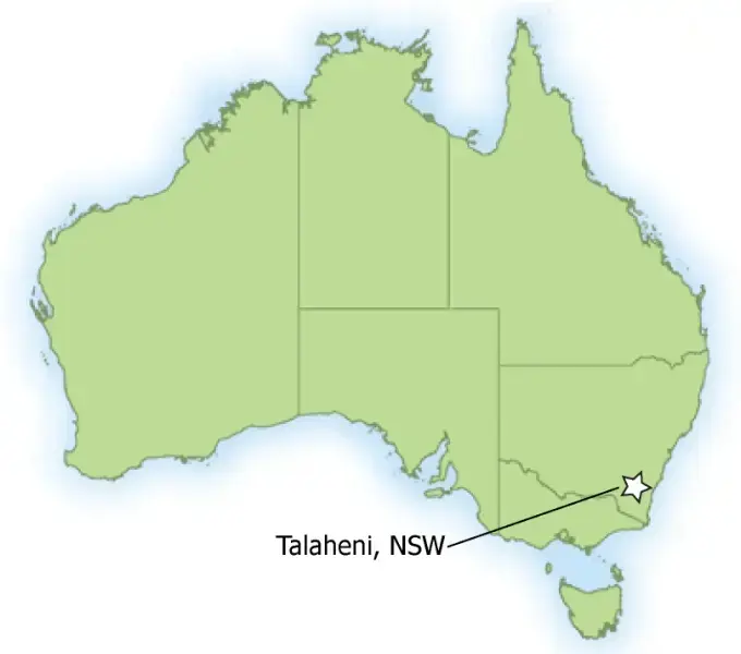
Near Murrumbateman, 40km north of Canberra, NSW Southern Tablelands
FARM FACTS
ENTERPRISE: Sheep, cattle, native trees. Ultra-fine Sharlea wool; Angus beef cattle; farm forestry
PROPERTY SIZE: 250 hectares=
AVERAGE ANNUAL RAINFALL: 625 mm
ELEVATION: 600 m
MOTIVATION FOR CHANGE: Non-viability of previous management and identifying the opportunity to apply practical ecological science
INNOVATIONS
- Revegetation to manage salinity
- Strategic paddock design
- Planned grazing strategies, particularly addressing fodder supply and drought conditions
- Innovations commenced: 1980
KEY RESULTS
- Increased available productive land through reduced water table levels eliminating saline seeps
- Specialist provider of ultrafine Sharlea wethers
- Revegetation of over 200,000 native trees
Introduction
The Ive family purchased Talaheni in 1980. At the time, the property was suffering from major dryland salinity caused by over clearing and exploitative land management practices. As a would-be ecologist, John saw the opportunity to repair the degraded landscape through revegetating the ridges and fixing the soil fertility problems that had built up over previous decades.
John and Robyn prepared a comprehensive plan to repair the land and achieve a profit from Talaheni. This addressed the fundamental need to understand the implications of variation in slope, aspect, soil depth, geology, vegetation and climate on achieving success.
Production improvements were experienced from 1983. Now, over 200,000 new trees and a niche production line later, the Ives manage the salinity as well as regular regional droughts with a healthy, resilient landscape. By taking a strategic approach and working with the land and the seasons, John and Robyn have transformed an “environmental and farming basket-case” into an enterprise that has received local, national and international recognition.
Comprehensive Planning
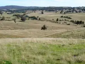
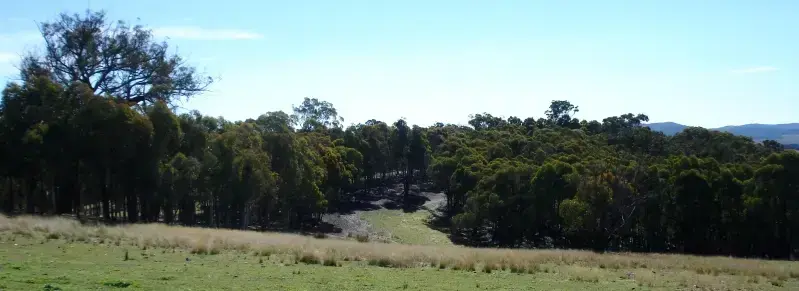
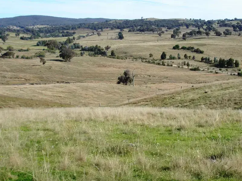
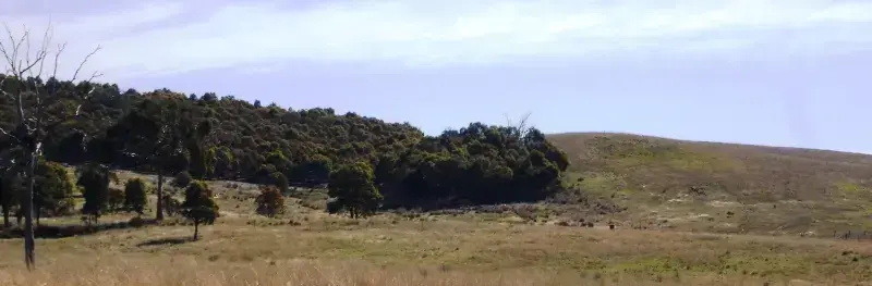
The current Talaheni landscape
In 1980 John and Robyn purchased the 250 hectare property in the Yass Valley, an area renowned for its dryland salinity problems. Their family farming background supplemented by agricultural college and tertiary qualifications in agricultural science and economics provided a sound basis for undertaking the makeover of Talaheni over the following three decades.
John and Robyn both realised at the time of purchase that previous management had been exploitive and would be non-viable into the future. However, they recognised an opportunity to apply sound practical ecological science to an unprofitable enterprise that had depleted the resource base.
To improve the landscape on Talaheni, John and Robyn drafted a plan that recognised major impediments to achieving production potential. Management practices were then identified to address key resource condition issues, such as the dryland salinity. Management of the elevated water tables was identified as a key priority in achieving this.
The plan was then progressively implemented as time and resources permitted, ensuring regular review and updating in response to progress.
A solid monitoring program was at the core of implementation to ensure that the farm plan was achieving intentions. Where possible this was introduced before changing management so that the effect of changing practice could be quantified. As John says, “If you do not measure it you cannot manage it”.
Various factors are regularly monitored, including vegetation transects, salinity levels in dams and weekly measurements of the water table. The Ives have now achieved ISO14001 accreditation for their Environmental Management System.
Combined with their farm plan addressing production limitations, John and Robyn set out to develop a production niche suited to the ecological function of the area.
The niche identified was ultra-fine wool production and the development of a sharlea wether market. Sharlea wool is produced by Saxon Merino sheep which are housed in specially constructed sheep care sheds where all aspects of proper sheep husbandry, nutrition and feeding, health, wool growth, quality and cleanliness are exercised between each shearing. The movement from a normal regional fine Merino flock to a highly respected ultra-fine flock has diminished threats to Talaheni’s viability, and, as John reports, “As a result we are now a sought after specialist provider of sharlea wethers for shedded sheep operators in southern Australia”.
John and Robyn have developed marketing strategies to ensure price returns meet their financial requirements. Angus steers are also produced for the beef cattle feedlot market.
By strategically planning production, including specifically-designed grazing and vegetation management techniques, John and Robyn have regenerated Talaheni, and built resilience into their landscape. They believe that environmental restoration is a necessary precursor to achieving production potential.
Advice has been sought from a wide range of sources throughout the regeneration process, such as from farming colleagues and agencies, but not always adopted. John and Robyn were initially told that overcoming their salinity problem by revegetating the ridges was impractical. They nevertheless went ahead with the plan, which has been demonstrated to be highly successful.
Improvements have been undertaken in a prioritised manner as funds have become available. Almost all work on Talaheni, such as fencing, pasture establishment, yard and building construction, has been undertaken by family members. Off-farm labour has only been used for shearing, fertiliser spreading and major earthworks for dams and contour banks.
John and Robyn also have an eye to considering wider issues for their farm, “In order to be better prepared for future climate change we have calculated that a two degree increase in average temperature, which might not seem much, would increase the average time above plant wilting point threshold [when they can no longer draw moisture from the soil] from 52 to 62 per cent of the time. Faced with this likelihood, we are trialling pastures that are more drought resistant”.
Background
HISTORY OF TALAHENI
The area where Talaheni is located (Nanima), was first settled in the 1840s or 1850s. A gold mine, Xanadu, operated by Chinese people, was worked later in the 19th century. The gold was in narrow quartz veins and extraction required a steam-driven mill. Trees were felled for fuel for the boilers and an aqueduct was constructed to carry water to the site from the Yass River.
When gold mining was no longer economical, the miners turned to ring-barking and clearing the regrowth resulting from their felling.
By the turn of the century there was a dairy farm working next door to what is now Talaheni. Milk was carried by horse back to Canberra.
Since the early 1900s wool production in the area proved to be profitable, with graziers over numerous decades achieving record prices due to the excellent quality of the fine wool produced from the area.
Changing Practices
STRATEGIC PADDOCK DESIGN & MANAGEMENT
The Talaheni landscape is composed of highly folded and deeply dipping Ordovician metasediments with rocky hills interspaced by contrasting weathered valleys. With this landscape, John and Robyn believed that good management called for the different landscape elements, for instance hills and valleys, to be fenced separately, so that management could be correctly targeted throughout the year to maximise pasture growth and grazing opportunities. John and Robyn have subsequently more than quadrupled the number of paddocks originally at Talaheni. Each paddock was strategically planned taking into consideration variation in slope, aspect, soil depth, geology and vegetation. Now with their own water supply, each of these is carefully managed.
John describes, “At Talaheni we have gone from a chequerboard layout of nine paddocks to 38 resource-defined paddocks. Only one fence remains on its original alignment, the rest being pulled out and realigned to achieve the landscape separation we sought. A central laneway provides an efficient way to move stock around the property”.
Each paddock is now relatively uniform in landscape and soil characteristics such as slope, aspect and soil depth. Paddocks on the lower slopes and flats with deeper soils and more favourable soil moisture conditions now support productive exotic perennial species, primarily Phalaris aquatica pasture. The mid-slopes of the property support native perennial species, particularly pastures of weeping meadow grass (Microlaena stipoides). The hilltops, which 25 years ago only held a few aging trees that had survived earlier clearing, now have native tree vegetation cover.
This strategic design makes for easier decision making when selecting the best vegetation system and management for each paddock. In one case, fencing of a prominent hill to recognise different aspects has provided around four weeks extra green fodder for stock by preventing them abandoning the northerly area at the first sign of haying-off in preference for the increasingly more attractive southerly aspect.
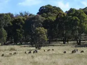
Sheep grazing patterns have been exploited to help regenerate hilltops during periods of drought.
John elaborates, “We divided a large paddock surrounding a hill into several smaller fenced sectors. Strategic grazing for short periods extends the productive grazing of the pastures by several weeks. Rather than allowing the stock to selectively and repeatedly graze the greener pastures, we can keep the stock on the more exposed side of the hill early in the season and move them sector by sector towards the more protected slopes as the pasture dries off”.
Strategic grazing enables pasture productivity to be optimised to match the seasonal conditions and herd and flock husbandry needs. The Ives employ brief heavy grazing, resting at least 25% of property at any one time.
John and Robyn’s approach to managing drought is particularly interesting. They consciously determine which parts of Talaheni are least likely to degrade during these trying times.
John explains, “The silent partner [the land] suffers when the business is failing. This is particularly the case with drought. During drought periods, we move the sheep from the erosion prone areas, which are the more productive flats and mid-slopes, to hilltop paddocks that become ‘sacrificial areas’. Here the stock are concentrated and hand fed throughout the drought. During this time the stock also eat out any remaining forage on these areas”.
“The logic of our approach is that these areas are not as vulnerable to erosion because of their high-in-the-landscape position and stony nature even when almost bare, they are however the sites of high recharge potential and cannot support productive pastures. This may seem a detrimental management practice. Our decision to protect the more productive pastures on erodible soils from grazing pressure during these hard times enables them to respond quickly once the drought breaks.”
With the onset of drought-breaking rains fuelling good pasture growth on the flats and mid-slopes, the hilltops are then destocked and stock moved down to these recovering areas.
“Grazing on the hilltops removes competition from grasses and forbs, leaving the seeds produced by the few remaining hilltop trees – which appear to have an innate ability to produce lots of seed in such periods – to germinate and establish with minimal competition. Given this setting, our experience is that eucalypt germination events are ‘like the hairs on a dog’s back’.”
With stock numbers reduced due to the drought, such areas can then be spelled possibly for many months as flocks and herds rebuild away from these areas, allowing the young trees to become well established without any setback from grazing. If grazing is required from these areas then John and Robyn prefer to pulse graze with stock introduced at very high stocking rates for relatively short periods so they graze the re-establishing grasses and forbs but are removed before any permanent damage occurs to the trees.
Vegetation Management
REDUCING SALINITY THROUGH REVEGETATING THE RIDGES
… we have ‘established’ more than 200,000 trees at very little cost on most inhospitable sites.
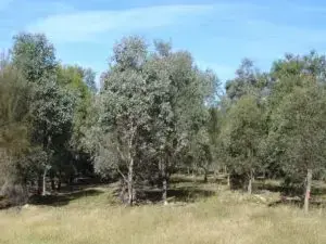
Talaheni comprises 250 hectares of rolling to hilly terrain. Prior to conversion to intensive grazing, the land cover was forest and grassy woodland. The main tree species were red box (Eucalyptus polyanthemos), red stringybark (Eucalyptus macrorhyncha), and brittle gum (Eucalyptus mannifera). The majority of pastures are native perennial grasses.
John and Robyn believed from early on that they could reduce their salinity problems by lowering the water table through utilising more water higher on their property. Revegetating the ridges was seen as the way to reduce rainfall infiltrating to the water table. The water table would then be lowered to below the level where saline groundwater could seep to the surface on the potentially productive lower flats.
Over time, this technique has reversed the extensive dryland salinity that had appeared on the property over the previous decades. Without the surface saline seeps, the loss of vegetation cover has been repaired and sheet and gully erosion has reduced.
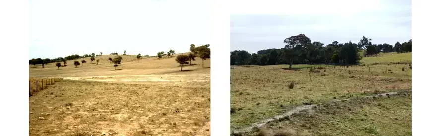
Left: In 1982, Talaheni was bare with visible saline seeps. Right: In 2012, revegetation has reduced salinity and pastures are healthy. Initial swales are visible across the lower right of the image.
As part of their grazing strategy, the revegetation has been achieved by intensively grazing ridge areas to maximise ground disturbance and then removing the sheep for one to two years. Tree seeds can germinate readily on disturbed ground and have a chance to establish if the sheep are kept off for long enough.
Where there were insufficient remaining trees to provide seed, seedlings were planted in multiple row strips. The ground was prepared by ripping with a bulldozer to break open the rocky and compacted soils and to enable tree roots to penetrate. Species with potential for quality timber production were included in these tree belts so that, in the long-term, there would be scope for a potential additional source of revenue from timber.
Where there were insufficient seeds for natural regeneration, tree seedlings were planted, including species for possible timber production.
Understanding the land and climate has helped John and Robyn exploit conditions, such as drought, to achieve their goals through grazing management. “While there is little one can do to influence the progress of a drought, we must remain vigilant and take full advantage of any benefits. For landholders wanting to increase tree cover on their properties, drought can get the green revegetation wheel rolling with very little effort when resources are sorely stretched. This has been our experience during the dry times over the past 25 years. We estimate that we have established more than 200,000 locally native trees by exploiting seed production through the drought, with very little effort on our part”, John says.
Any growth is also managed with strategic goals in mind. John explains, “Where we observe excessive re-establishment of tree seedlings on areas with pasture potential then these areas may be managed to remove or reduce tree cover. The approach used depends upon the size of the area and timing. Tools in the armoury include mattocking, spot spraying with herbicide, bull blading and stem injection of herbicide, either singly or in combination to spread the workload over time. Areas are assessed to identify the better soils and flagging tape used to distinguish ‘good’ from ‘bad’ areas for easier spotting when removing trees. Where more than one species has re-established, the composition of the stand can be influenced also at this stage. In our case, red box, when present, is preferred to red stringybark. Later still, selective thinning is employed to achieve a vigorous and more sustainable stand density while providing sturdy poles and timber for farm and off-farm use”.
“Using this approach we have ‘established’ more than 200,000 trees at very little cost on most inhospitable sites. This compares with about 20,000 seedlings planted by hand, representing a labour intensive and timing critical process over the same period.”
The hilltop trees now cover the areas with the highest recharge potential and as they grow they continue to “tighten the screw on the recharge tap” and reduce the incidence of dryland salinity on the lower and more productive flats enabling successful establishment of vigorous exotic perennial pastures.
It is estimated that each hectare of ridge top that was revegetated has led to a beneficial lowering of the watertable over 50 hectares of nearby adjoining flats, much of which is on neighbouring properties.
The Ive’s ridgeline regeneration success is apparent at their fenceline with neighbouring properties.
Soil Management
TALAHENI SOIL
When John and Robyn purchased Talaheni 30 years ago the soil health was poor. Nutrient levels were low, as was pH, at around 3.6 in some areas. Soil carbon levels of below 1% meant infiltration and water holding capacity were poor. Aluminium levels were high. High groundwater levels led to saline seeps across a substantial proportion of the property and as a consequence, much of the property suffered from sheet and gully erosion.
Some of these aspects are a natural feature of Talaheni soils, which have been derived from nutrient poor Ordovician metasediments. Landscape cross sections range from ridge top lithosols passing through gravelly shallow red podzolics, to shallow to moderately deep red podozolics to soloths and solodics on the flats.
To improve the soil health, the Ives have added sulphur-enriched reactive rock phosphate and Canberra sewage ash and lime have been used to address pH levels. Poultry manure and gypsum have been applied to assist in improving soil physical properties. Combined with the benefits of increased ground cover and vegetation, soil phosphorus and sulphur levels have increased, as have soil carbon levels. In some of the healthiest areas, soil carbon has recently been measured at 4%. John and Robyn maintain soil nutrient status records, and have over 30 years of periodic sampling data.
Water Management
TALAHENI WATER
…management of water tables has all but eliminated saline seeps.
Talaheni has no permanent or ephemeral streams so water supplies depend on a network of dams and tanks on buildings. Construction of the dams was often associated with complementary contour and graded banks. Dams were frequently installed at points where serious gullies were previously active and have been made as deep as possible with as small a surface area as possible to minimise evaporation losses. Contour and graded banks control water movement through the landscape and reduce risk of soil erosion while increasing the opportunity for retaining water on property. Where limited cultivation has been undertaken, this has been done on the contour. Areas with high runoff potential on steep slopes have been ripped at intervals to a depth of 70cm to assist rainfall infiltration and ultimately pasture growth where salinity risk was low.
The low plant-available soil moisture holding capacity, averaging around 60mm, made it a priority to retain as much moisture in the profile where it falls for use by pasture. Accordingly, continuous groundcover has been sought where possible. John notes, “A daily soil water balance ‘WATERBANK’ model has been developed to give a greater understanding of the fate of rainfall and to aid routine management and timing of operations”.
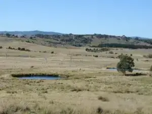
To minimise evaporation, dams were made as deep as possible with small surface areas.
Improved soils and water monitoring helps the Ives to manage their variable annual rainfall, which, in the last ten years, has ranged from 363mm in 2006 to 967mm in 2010.
Saline seeps were previously common across Talaheni. High recharge on rocky ridge tops lead to expression of dryland salinity on potentially more productive lower flats. Consequently, water management was initially viewed as the most vital management challenge by John and Robyn. Now, their management of water tables has all but eliminated saline seeps.
The significant revegetation of Talaheni ridges has reduced rainfall deep drainage to the water table, lowering it to below the level where saline groundwater can seep to the surface. The installation of a network of piezometers (devices which measure groundwater pressure and water table height) more than 20 years ago and weekly monitoring has provided a great understanding of the response to this and other on-farm actions to reduce recharge. Documented evidence shows the significant decline in watertable levels and an equally impressive decline in salinity levels of groundwater.
Outcomes
SUCCESS AT HOME & ABROAD
One needs to develop the skills to read one’s own landscape…
Production increases began to be experienced only a few years after John and Robyn commenced implementation of their plan to repair Talaheni. John summarises, “We started implementing the plan in 1980, and in terms of stock numbers there has been a steady rise since 1983 (trend line 0.15 DSE/ha per year increase). Wool production increase – taking into account wool cut and fibre diameter – has a trend line increase since 1985 at 38 units a year. Cattle weaning weight, adjusted for age, birth date, sex, age of cow trend line has increased at 1kg a year since 1985. These trends continue to the present, when seasonal impacts are removed. Visually change was apparent in 1984. With an above average season we managed to get good groundcover with gullies having been filled and contour and graded banks functioning to slow water movement through landscape”.
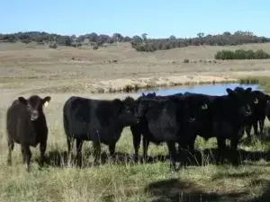
Angus beef provides a supplementary production line to ultrafine wool.
A feature of Talaheni has been the protection of remnants of dry sclerophyll woodland, native forests which typically consist of multi-aged stands of eucalypts with an understorey dominated by hard leafed shrubs, grasses, sedges or bracken fern. The health of native vegetation has improved with major recruitment of new trees as result of the Ive’s innovative management practices. Where seed trees do not exist, hand planting has been successful in establishing a corridor network of linking native vegetation.
Overall, around 20,000 native species trees have been planted over the past 30 years, plus an estimated 200,000 trees have been established naturally by the strategic grazing and rest management exploiting variable seasonal conditions. This technique has been documented and subsequently adopted by other landholders.
Measurement and monitoring are important features of the implementation of the Ive’s plan for Talaheni. Transects have been established and vegetation periodically monitored. Regular bird surveys have been undertaken resulting in a current and growing inventory of 125 species. Third-party studies of native ant populations, which are bio-indicators, reveal healthy conditions. Fencing out of remnants and exclusion of domestic grazing together with establishment of linking native vegetation corridors continues to enhance the quality of animal and plant life in the region, and previously moribund trees have recovered.
Initial large areas of serrated tussock (Nassella trichotoma) and black thistle (Cirsium vulgare) indicated degraded pastures. However over the years the Ive family have worked to improve the per cent of ground covered by pastures and to control major weeds using a targeted spraying program. In addition, every farm vehicle always carries a small mattock and a culture of digging out plants where ever seen during normal farm activities anytime throughout the year has been established.
Using this approach, major weeds found in the district such as serrated tussock, black thistle, fleabane (Conyza sumatrensis) and St Johns wort (Hypericum perforatum) are a relatively minor problem. John notes, “Although these weeds are not totally eradicated, due largely to wind-blown seed migrating from adjoining properties, control these days is a minor task”.
Successful land managers adapt by adopting production and land management systems appropriate to the circumstances, the markets and the environment.
The success of Talaheni has been widely recognised locally, regionally, nationally and internationally. Results from a number of collaborative on-farm trials with different agencies continue to be used to promote new or amended practices throughout the region and are the focus for regular on-farm field days.
John and Robyn have experienced the steady receipt of some 27 awards for farming achievements over the past 30 years – the most recent was the National Carbon Cocky Award in September 2011. National and international press have carried stories of Talaheni – one article appeared simultaneously in the New York Times and Chinese Peoples Daily.
As a result of such achievements, John and Robyn are regularly asked to provide on and off farm presentations to groups from across south eastern Australia and overseas. They also serve on a number of industry and state committees dealing with resource issues, such as the AWI Wool Carbon Alliance.
John summarises, “The journey has been an immensely gratifying one as Talaheni has been transformed from an environmental and farming basket-case to an enterprise that attracts interest from near and far and continues to be recognised with the receipt of awards and invitations to present to farming and agency audiences across southern Australia”.
WORDS OF ADVICE
John points out the importance of embracing change in improving land management practices, “People are reluctant to consider and embrace new approaches because of ingrained attitudes. In our view, change is inevitable. Successful land managers adapt by adopting production and land management systems appropriate to the circumstances, the markets and the environment. By resisting change and sticking with the old ways the silent partner, that is, the land, suffers”.
John and Robyn believe that there is no single right way to improve land management. “Our desire is that people reading about Talaheni shouldn’t consider Talaheni as a place for rote learning, but should study the principles and apply them to their circumstances.” They recommend that, “One needs to develop the skills to read one’s own landscape and the processes involved and then seek to address the limiting and declining factors supported by a sound monitoring program. Although this may draw upon experiences and recommendations of others, the adoption of established management approaches in a rote-like manner is fraught with danger and not encouraged”.
Likewise the term ‘best practice’ is not encouraged by John and Robyn due to the finality it implies. They say, “Rather, practices should be seen more in the dynamic vane of a rainbow – although always in sight, they remain elusive but tantalisingly achievable as new and better understanding moves the destination”.