

Water management in the land of droughts and flooding rains: Lessons from our case studies in low rainfall areas
Managing grazing pressure, maintaining soil fertility, controlling weeds … the list of challenges facing agricultural land managers could go on and on. But, arguably the biggie, the black beast always lurking out there, is water. Sometimes there is too much of it, but that is rare in our land of droughts and flooding rains. Usually the problem is that there isn’t enough. Perhaps a solution in some circumstances is to focus on the flooding rains.
This article looks at the different approaches taken on our case study properties to manage big falls of rain when they come. It is evident from the range of approaches mentioned across all our case studies that there are creative ways to make the most of the available rainfall. The principle shared by each of the examples is an approach that slows the movement of water and allows it to seep into the soil. The ways and means vary depending on the land itself and resources available.
Water management: Scalds on Salisbury
Soils For Life’s Salisbury case study, about the MacAlpine family’s property in the north of central-western New South Wales illustrates the problem, and the potential solution. Salisbury and several prior case studies provide lessons in water management that might be useful for many agricultural land managers.
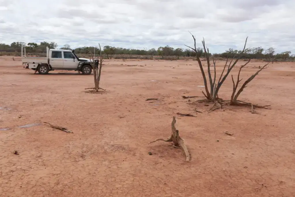
There are no permanent watercourses on Salisbury. Water supply is rain and bores that tap the Great Artesian Basin. Average annual rainfall is about 450 mm, probably less. The average and median monthly rainfall sometimes falls in a single day, sometimes causing regional flooding. Conversely, little or no rain falls for substantial periods. As if that doesn’t make life complicated enough, there are also the ‘scalds’ to deal with.
The early period of sheep grazing in the arid and semi-arid rangelands of western New South Wales was a disaster for topsoil. Overgrazing encouraged by high wool prices destroyed ground cover, which in dry periods led to widespread wind and water erosion that created ‘scalds’ where the coarser textured surface material has been completely lost, leaving the finer textured and less permeable subsoil [Figure 1]. This was reported as being an extensive problem as long ago as 1901 (Cunningham 1987). By the 1960s, tens of thousands of square kilometres of rangeland sites in western NSW were moderately bare or completely ‘scalded’ (Thompson 2008).
Water soaks into scalded land so slowly that soil moisture recharge, and the potential for revegetation, is negligible. The rare events of flooding rains do little more than cause more soil erosion. This land is perpetually barren, or would be without intervention.
Methods for reclaiming scalded soils in Western NSW have been researched since the late 1940s (Cunningham 1987). Surveying and construction methods developed over several decades have made rehabilitation of scalds more and more cost-effective (Rhodes 1987). These involve using a grader to build low ponding banks to hold rainwater to a depth of 10 cm or so. These are circular on flat ground and semi-circular (a ‘horseshoe’ shape) on scald with a mild slope. The opening of the horseshoe is to the up-slope side, so that run-off collects within the banks. Each pond covers about 0.4 hectares. The grader used to construct the banks is also used to disturb the soil surface within the ponds in strategic locations (Thompson 2008).
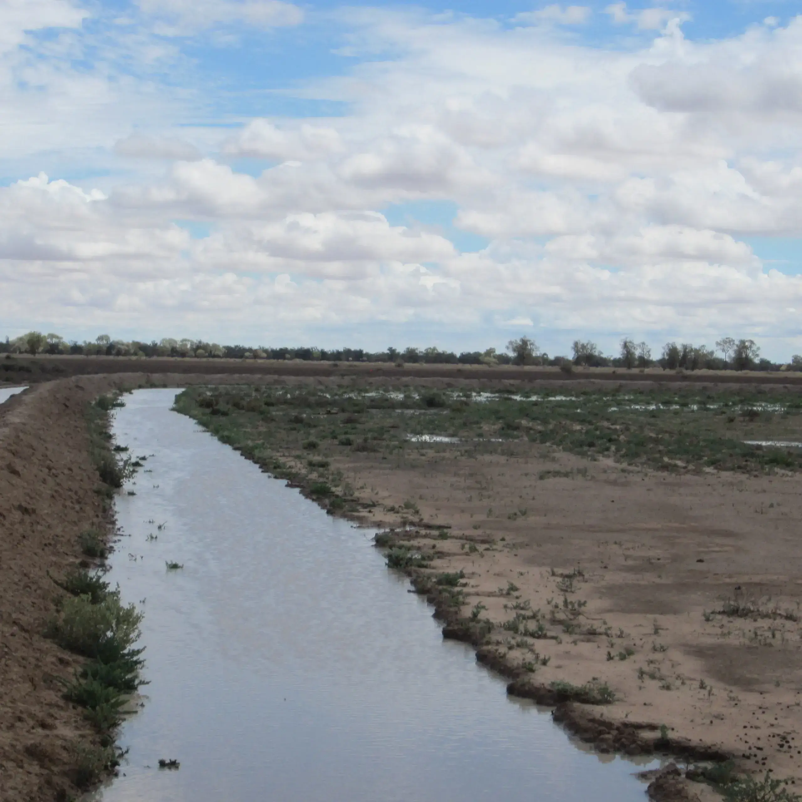
The effect of the ponding banks and disturbance is to hold water from the intermittent heavy falls. This then infiltrates – albeit slowly – to leach salts from the surface, recommence soil swelling and cracking and provide moisture down the soil profile. The banks and disturbance within the pond area provide a barrier to wind-blown sediments and plant material, which collects and starts to form an organic-rich surface layer. The saltbush seed, together with whatever other wind-blown or sheep- or bird-delivered seed arrives, then has somewhere to germinate and moisture to tap in the soil profile. The natural processes of ecological succession have effectively been given a ‘kick-start’ and can take their course.
The results on Salisbury can be seen in Figure 2.

Breaking the surface on Bokhara Plains
About 150 km north-west of Salisbury, on the Goodooga Road north of Brewarrina, is Bokhara Plains. In 1999 around 50% of the 7200 hectares property was clay pan or otherwise bare ground.Ponding had been tried on Bokhara Plains but, except at the edges of ponds where the soil had been disturbed, the effects were minimal. A cost-effective way to break up the hard capped surface to accelerate water penetration to capture the infrequent falls of rain was required.
The most cost-effective method found was to use cattle. The trick was, after a fall of rain when the surface was wet, to pack on a big enough mob of cattle so that the hooves could break the surface. However, because of the low carrying capacity on the property there weren’t sufficient numbers to do the job, so the landholders agisted cattle when the time was right to help break up the surface.
As well as Salisbury and Bokhara Plains, interventions to make the most of intermittent and unreliable rainfall have been implemented at Gilgunnia Station and Wyndham Station. Clay pans were not such a problem on these properties, further west in New South Wales, but the need to maximise the benefits of limited available rainfall is no less important. Rothesay, in the central west, illustrates the use of a similar technique in hillier country.
Water-spreading at Gilgunnia Station
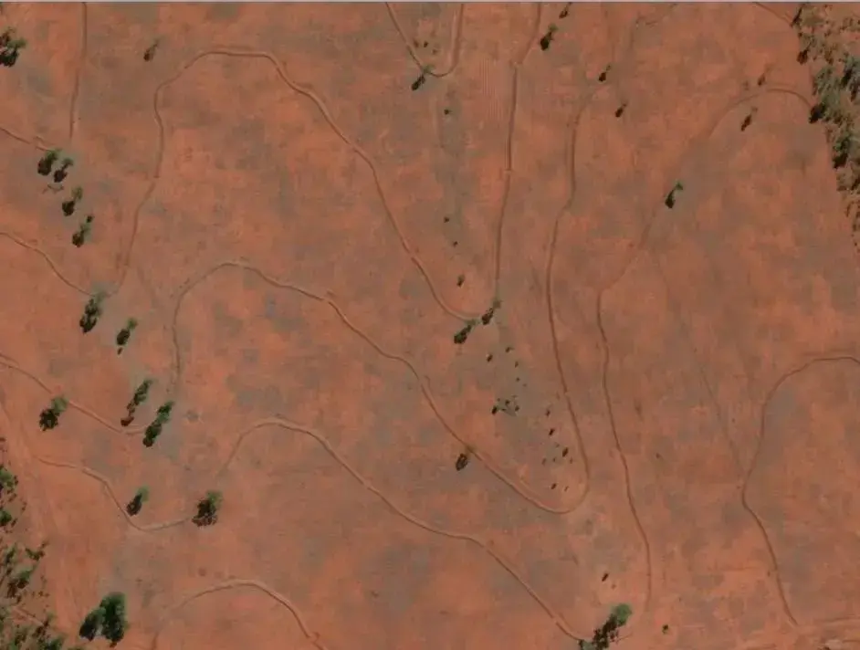
Gilgunnia comprises 10,000 hectares on the Cobar Peneplain. Rainfall ranges from 101 mm in 1982 to 710 mm in 2010, and averages 398 mm. As is common in the region, rainfall comes in heavy falls. Here, the tendency is for it to run off the gravelly rises and through the flats without infiltrating and therefore exacerbating soil erosion. To add to the soil erosion hazard, turpentine bush and other invasive native shrub and tree species had taken over the original grassy woodland, considerably reducing grazing capacity. Removing that vegetation posed the risk of increasing soil erosion. Landscape engineering in the form of water-spreading banks was implemented to help address these issues.
Water spreading is suited to broad flats between 100 metres and 1 kilometre wide. The system at Gilgunnia comprises concentric curved banks constructed along the contour, spaced a few hundred metres apart (Figure 3). The banks prevent runoff from accumulating down drainage lines, and therefore stabilise erosion, and increase water infiltration. A gap is left in the bank at alternating points along the length of each bank. Runoff ponds behind the banks and infiltrates through the gaps, making its way to and fro gradually down through the broad flats. Organic matter accumulates behind the banks, trapping seeds and accelerating revegetation.
Improving water distribution on Wyndham Station, Rothesay and Balala
Wyndham Station on the lower Darling River is even further west in New South Wales – in fact it’s not much further to get to South Australia. The average annual rainfall here is only 260 mm. Rothesay is in central NSW at the foothills of the Liverpool Plains, where the average annual rainfall is a rather more generous 691 mm. But the same problem arises: there are good years, and there are drought years.
The topography on Gilgunnia and at Rothesay is more pronounced than at Gilgunnia or Salisbury, so different solutions apply. Low banks and channels are constructed at a shallow down-grade from drainage lines towards the ridges. Runoff follows the channels and disperses down the slopes.
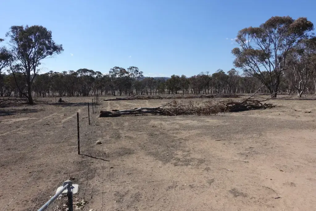
A different approach has been taken at Balala, west of Uralla in northern New South Wales. Following a long history of set stocking, woody native vegetation over substantial parts of Balala had become substantially denser than the original grassy woodland, to the extent that the grasses were suppressed and there was little grazing potential. Approval was obtained to thin some areas of overly dense stands. That helped pasture rejuvenation but created the problem that there was woody debris to deal with. Turning that problem into an asset, piles of stems and branches were laid along the contour on gentle slopes (Figure 4). The effect of the piles was to impede surface water flow, which increases infiltration, and to trap organic matter. As well as making better use of available rainfall, research has found that this method improves soil nitrogen and carbon content and nutrient exchange properties (Tongway and Ludwig 2006).
Bundles of woody debris or “Brush Packs” were installed in the Mulloon Creek catchment as part of the Green Army program. The Mulloon Institute produced a guide to the use of “Brush Packs” following the bushfires of 2019/20. Retaining organic matter and nutrients after fires increases the speed of landscape recovery and protects water systems.
References
Cunningham, G.M. 1987. Reclamation of scalded land in western New South Wales. Journal of Soil Conservation New South Wales, Vol. 3, number 2. Soil Conservation Service of NSW, Sydney.
Rhodes, D. 1987. Waterponding banks – design, layout and construction. Journal of Soil Conservation New South Wales, Vol. 3, number 2. Soil Conservation Service of NSW, Sydney.
Thompson, R. 2008. Waterponding: Reclamation technique for scalded duplex soils in western New South Wales rangelands. Ecological Management and Restoration 9: 170-181. doi: 10.1111/j.1442-8903.2008.00415.x
Tongway, D. and Ludwig, J. 2006. Rehabilitation of Semiarid Landscapes in Australia. I. Restoring Productive Soil Patches. Restoration Ecology. 4. 388–397. 10.1111/j.1526-100X.1996.tb00191.x.
